
Watch Duty Integrates with Planet to bring High-Resolution Satellite Imagery to Enterprises Like PG&E
Partnership brings Planet's cutting-edge earth observation capabilities to the nation's leading nonprofit wildfire and

Press Release Disclaimer: This is a press release distributed through the XPR Media network. It has not been independently verified by our newsroom.
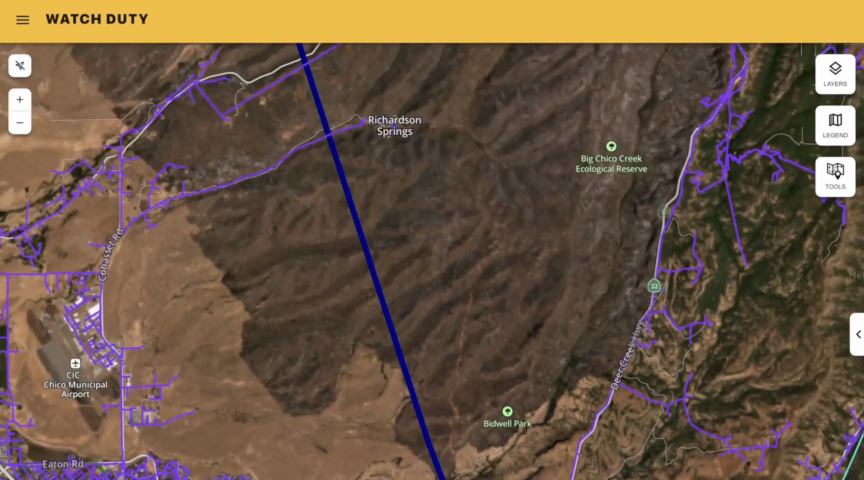

Partnership brings Planet’s cutting-edge earth observation capabilities to the nation’s leading nonprofit wildfire and flood information platform.
SAN FRANCISCO, CA, UNITED STATES, August 12, 2026 /EINPresswire.com/ — Partnership brings Planet’s cutting-edge earth observation capabilities to the nation’s leading nonprofit wildfire and flood information platform, designed to offer infrastructure operators the most recent satellite imagery of their coverage areas on the market
Watch Duty, the nonprofit public safety service trusted by millions across the United States for real-time wildfire and flooding information, today announced new enterprise features through an integration with Planet Labs PBC (NYSE:PL), a leading provider of daily data and insights about change on Earth.
As the 2026 wildfire season continues to reveal longer and more destructive activity across the U.S, companies with significant infrastructure like utilities and telecommunications firms are relying on accurate, real-time information to make critical de-energization and field coordination decisions.
Watch Duty is integrating Planet’s high-resolution weekly satellite mosaics as a map layer available within Watch Duty’s enterprise environment. Mutual enterprise customers who use this feature gain access for significantly more current on the ground reporting than existing satellite mapping solutions, which can be months but often years out of date.
Planet satellite imagery is overlaid on Watch Duty operational context, including incident data on wildfires and major floods, human-validated reporting, enterprise asset mapping, strengthening pre- and post-incident situational awareness for critical infrastructure clients. Now, Watch Duty enterprise customers leveraging Planet’s satellite data will have more current vegetation and fuel load visibility, as well as higher infrastructure corridor awareness. This higher resolution allows for better post-incident burn scar or flood damage assessment, with the potential to enable faster post-event damage restoration planning.
“When managing wildfires, time is of the essence,” said Will Marshall Co-Founder and CEO of Planet. “This integration combines Watch Duty’s vital on-the-ground context with Planet’s overhead view, empowering teams at utilities like PG&E to move from reactive crisis management to proactive solutions to help protect people, property, and the environment.”
“This layer is the most current on the market, so partners have enhanced visibility into critical infrastructure risks,’ said John Mills, Cofounder and CEO of Watch Duty. “Planet’s satellite data gives our enterprise customers a better look at current vegetation conditions, roadways, burn scars, and fuel breaks, all of which play key roles in critical decision making.”
Pacific Gas and Electric Company (PG&E) has become the first adopter of the new integration features, utilizing the technology for more current, high-resolution imagery of its service area directly within Watch Duty’s common operating picture. This gives PG&E teams a stronger baseline to assess vegetation conditions, identify changes to terrain, evaluate road and route changes, and support any needed incident investigations, all in context of their existing distribution and transmission line layers.
“Our teams rely on timely, accurate information to understand wildfire events and conditions in the field. Having access to more current satellite imagery alongside our infrastructure in Watch Duty helps us build a more complete picture, make informed decisions and continue strengthening our wildfire mitigation efforts,” said PG&E Wildfire Mitigation Vice President Andy Abranches.
The organizations expect to collaborate on additional capabilities over time, including enhanced mapping, analysis, and broader disaster response applications. While PG&E is the first user of this integration, this feature is available for any Watch Duty and Planet enterprise customer, designed especially for utilities, telecom infrastructure operators, and critical infrastructure managers.
About Watch Duty
Watch Duty is a 501(c)(3) nonprofit that delivers real-time alerts and situational intelligence for wildfires and floods across all 50 U.S. states. Its nationwide network of active and retired firefighters, dispatchers, and emergency responders monitor radio traffic and verified sources around the clock, supported by technology that scans publicly available data. Watch Duty’s work supports millions of residents, first responders, and emergency managers and has been featured as Fast Company’s #1 most innovative nonprofit and among TIME’s 100 Most Influential Companies.
About Planet Labs PBC
Planet is a leading provider of global, daily satellite imagery and geospatial solutions. Planet is driven by a mission to image the world every day, and make change visible, accessible and actionable. Founded in 2010 by three NASA scientists, Planet designs, builds, and operates the largest Earth observation fleet of imaging satellites. Planet provides mission-critical data, advanced insights, and software solutions to customers comprising the world’s leading agriculture, forestry, intelligence, education and finance companies and government agencies, enabling users to simply and effectively derive unique value from satellite imagery. Planet is a public benefit corporation listed on the New York Stock Exchange as PL. To learn more visit www.planet.com and follow us on X, LinkedIn, or tune in to HBO’s ‘Wild Wild Space’.
About PG&E
Pacific Gas and Electric Company, a subsidiary of PG&E Corporation (NYSE: PCG), is a combined natural gas and electric utility serving more than sixteen million people across 70,000 square miles in Northern and Central California. For more information, visit pge.com and pge.com/news.
Ruthie Glauber
Watch Duty
press@watchduty.org
Visit us on social media:
LinkedIn
Bluesky
Instagram
Facebook
YouTube
X
VIDEO: Watch Duty integrates with Planet on high-resolution satellite imagery
Legal Disclaimer:
EIN Presswire provides this news content “as is” without warranty of any kind. We do not accept any responsibility or liability
for the accuracy, content, images, videos, licenses, completeness, legality, or reliability of the information contained in this
article. If you have any complaints or copyright issues related to this article, kindly contact the author above.

Media gallery

