Vortex Energy Receives Final Technical Study Results for the Robinsons River Salt Project
Study confirms western salt structure, identifies an eastern exploration target and establishes a staged technical

Press Release Disclaimer: This is a press release distributed through the XPR Media network. It has not been independently verified by our newsroom.

VANCOUVER, British Columbia, Aug. 06, 2026 (GLOBE NEWSWIRE) — Vortex Energy Corp. (CSE: VRTX) (OTC: VTECF) (FSE: AA3) (“Vortex” or the “Company”) is pleased to announce, further to its news release dated July 16, 2026, that it has received the final technical study prepared by Lonquist Field Service (Canada), ULC (“Lonquist”) for the Company’s Robinsons River Salt Project (the “Project”), located approximately 35 kilometres south of Stephenville, Newfoundland and Labrador. The study integrates available geological, seismic, gravity and drilling information to refine the interpretation of the Project’s subsurface salt structures, assess available information regarding salt quality, identify potential future drilling targets and recommend a staged program of further technical work. The Company notes that the study was not prepared pursuant to NI 43-101, nor by a Qualified Person (as such term is defined in NI 43-101).
Highlights
- Seismic, gravity and drilling data support the presence of a substantial western salt structure, with the 2024 drill hole VTX-24-W-02 intersecting an interval of approximately 278 m gross salt.
- Seismic interpretation identifies a potential incremental step-out west of VTX-24-W-02 where the salt section may reach approximately 350 metres in thickness.
- Reprocessed gravity data indicate a large, untested eastern target that may be deeper and potentially contain cleaner salt than the currently drilled western structure; this interpretation is based on gravity data and remains unconfirmed by drilling.
- Next steps include detailed core analysis, source-water and disposal studies and technical planning.
The study confirms that Robinsons River hosts a thick halite-bearing system and identifies additional exploration potential, particularly within the untested eastern block. It also establishes a clearer framework for evaluating salt quality, subsurface geometry, drilling risk and potential commercial applications. Additional technical work will be required before the Company can determine whether the Project is suitable for commercial salt production, brine production or underground energy storage. No mineral resource or reserve, commercial production rate, storage-cavern design, storage capacity or economic evaluation has been established for the Project.
Geological and Geophysical Interpretation
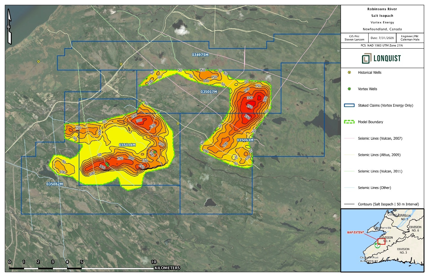
Figure 1 presents the final gravity-inversion salt-thickness model, and Figure 2 presents the spatial differences between the seismic-derived and gravity-inversion interpretations. The latest Robinsons River interpretation incorporates legacy seismic surveys, airborne and surface gravity data, historical well information and the results of the Company’s recent drilling program. The study concluded that the western salt block is supported by the strongest combination of seismic, gravity and drilling control, with VTX-24-W-02 confirming the presence of a substantial halite-bearing interval within the interpreted structure.
The study found that VTX-24-W-02 intersected an approximately 278-metre gross salt interval. The term “gross salt interval” includes the broader halite-bearing interval and should not be interpreted as 278 metres of continuous, high-purity halite. Legacy seismic data are considered sufficient to map the interpreted minimum extent of the western structure and indicate that the salt section may thicken locally toward a potential step-out target west of VTX-24-W-02. This proposed “Cloverleaf” location would represent an incremental step-out from the existing well and has an interpreted salt thickness of approximately 350 metres.
As part of the study, previously acquired airborne gravity data were reprocessed after it was determined that the original processing had used an inappropriate terrain-correction. Revised terrain corrections were incorporated into an updated gravity inversion, providing an appropriate basis for comparing the gravity response with the seismic interpretation. Based on the seismic interpretation, the final gravity inversion used fixed assumptions for the geometry of the Ship Cove Limestone structure and an assumed salt density of 2.30 grams per cubic centimetre. Under those assumptions, the model indicates additional potential salt east of VTX-24-W-02 and comparatively less salt immediately west of the drill hole than represented by the seismic salt isochore model. The seismic and gravity datasets therefore provide related but not identical interpretations. Seismic data support the Cloverleaf step-out west of VTX-24-W-02, while the gravity-difference model indicates that the most substantial additional salt volume may occur farther east. These differences reflect the indirect nature of both datasets and will require additional density information and drilling control to resolve.
The updated interpretation also identifies a western gravity anomaly beyond the currently defined salt structure and a larger eastern exploration target. The western anomaly is supported by gravity but occurs in an area where the available seismic data are considered marginal in quality. The eastern target occurs where a broad gravity low broadly coincides with seismic features interpreted as possible salt. The seismic support for this target is considered to be ambiguous. The prospective top of the eastern salt structure may occur approximately 1,100 to 1,300 metres below surface, and remains untested by drilling.
The western block is considered to be shallower, closer to existing infrastructure and supported by a higher level of geological confidence. The eastern block is farther from infrastructure and deeper, but the gravity response may indicate a greater proportion of lower-density material and therefore potentially cleaner salt. This remains an exploration hypothesis and has not been confirmed through drilling, core analysis or open-hole density logging.
Figure 1. Final gravity-inversion salt-thickness model for the Robinsons River Salt Project, showing the drill-tested western block and the untested western and eastern gravity anomalies. Contours represent modelled gross salt-interval thickness in metres. The inversion assumes a fixed geometry for the Ship Cove Limestone structure and a salt density of 2.30 grams per cubic centimetre. The mapped thicknesses are interpretive, have not been verified throughout by drilling and do not constitute a mineral resource or mineral reserve estimate.
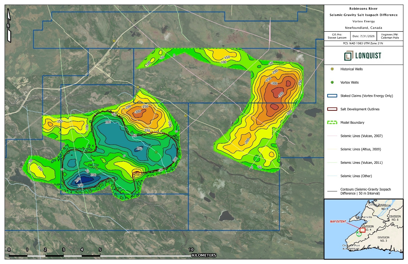
Figure 2. Difference between seismic-derived and gravity-inversion salt-thickness models, calculated as seismic-derived thickness minus gravity-inversion thickness. Negative values indicate areas where the gravity inversion models a thicker salt interval than the seismic interpretation, while positive values indicate the reverse. Values are expressed in metres and represent model-to-model differences, not measured salt thickness.
Salt Quality
The study reviewed the available descriptions of the VTX-24-W-02 core to provide a preliminary assessment of salt quality. The study describes the interval from 327.0 to 516.5 metres as a heterogeneous halite-bearing interval dominated by dark grey to black halite, with frequent mudstone interbeds, muddy salt, mud skins, fractures and minor cleaner translucent salt veins. Several comparatively thick intervals were described as higher-quality salt; however, mud-rich salt and salt-cemented mudstone intervals may materially reduce the overall salt percentage and influence the suitability of the deposit for potential commercial applications.
Based solely on the available core descriptions, a preliminary, high-level assumption was made that salt may comprise approximately 65% to 75% by volume within the evaluated interval. This estimate is not based on systematic whole-interval chemical assays, does not represent a mineral-resource estimate and does not establish recoverable salt tonnage or suitability for cavern development. Detailed review of the existing core, measurement of representative rock densities and determination of the salt percentage by volume are recommended before the Company makes a decision regarding additional drilling.
The approximately 278-metre gross salt interval extends from approximately 327 to 605 metres and is based on the broader lithological record. The detailed descriptions used for the preliminary salt-quality review cover the 189.5-metre interval from 327.0 to 516.5 metres. Detailed review of the complete core record is required to quantify halite, mudstone and other insoluble material throughout the full gross interval.
The study also noted that available descriptions from VTX-23-W-01 identified intervals containing more than 20% insoluble material. The existing information therefore indicates that salt quality is unlikely to be homogeneous across the interpreted structures. Higher-purity and laterally continuous salt would generally reduce uncertainty associated with solution mining and potential cavern development, while mudstone interbeds, insoluble material and structural variability may affect dissolution behaviour, cavern geometry, operating performance and development risk.
The study concludes that the western block appears to contain salt of moderate quality and that additional drilling may improve confidence in the geological model without necessarily identifying materially better salt. The eastern target may contain cleaner salt; however, this interpretation remains based on gravity data and is unverified. The study further noted that, relative to certain regional analogues, the currently available information indicates less favourable conditions for commercial viability and funding confidence at Robinsons River, and that encountering cleaner salt alone may not materially improve overall project confidence.
Study Recommendations
Figure 3 presents three conceptual target locations. The study identified the eastern target as the highest-priority conceptual exploration target because it offers the opportunity to confirm the depth, thickness and quality of the untested eastern structure. The western gravity anomaly represents a secondary target that is closer to infrastructure but has weaker seismic support and may contain salt of comparable or lower quality than the established western block. Additional drilling within the western block could improve confidence in the geological and gravity models but is considered unlikely to materially improve the currently interpreted salt quality.
Before advancing further drilling, the report recommends a staged technical program using the existing core and datasets. Initial work would include detailed description and analysis of the VTX-24-W-02 core, representative density measurements, determination of salt percentage by volume, and evaluation of freshwater availability and disposal capacity. If the Company elects to proceed toward additional drilling or cavern evaluation, subsequent work could include detailed well design and risk planning, an updated geological and geophysical model, geomechanical and cavern-suitability studies, and a field and storage-capacity assessment.
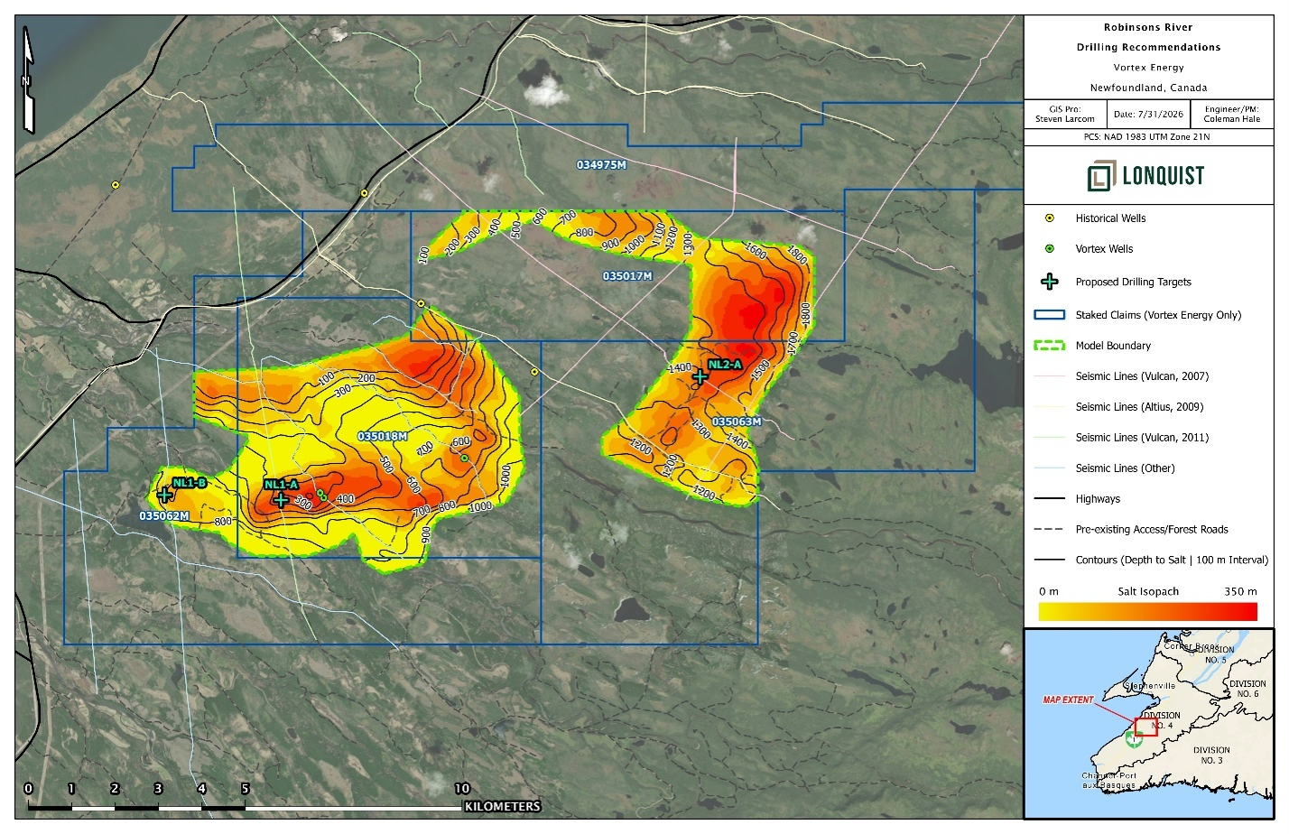
Figure 3. Conceptual exploration target locations identified in the study, including NL1-A, NL1-B and NL2-A, shown in relation to modelled gross salt-interval thickness, modelled depth-to-top-of-salt contours, existing drill holes, seismic coverage, mapped roads and Vortex claim boundaries. The locations are approximate planning concepts and do not represent approved drill sites. NL2-A is located within the untested eastern exploration target.
The Company notes that it has not completed a preliminary economic assessment, pre-feasibility study, feasibility study or comparable economic evaluation for the Project. There is no assurance that the interpreted salt structures will support commercial salt extraction, brine production, hydrogen storage, compressed-air energy storage or any other underground-storage application.
“Lonquist’s work has provided Vortex with a much clearer and more disciplined framework to advance the Robinsons River Project,” said Paul Sparkes, Chief Executive Officer of Vortex. “The study has reinforced confidence that a substantial salt-bearing system is likely located in the western block and identified meaningful exploration potential to the east. We now have an outline of practical steps that can be taken to reduce technical uncertainty before committing to another major drilling campaign. Our immediate focus will be on extracting the maximum value from the existing core and technical datasets.”
Company’s Next Steps
The Company will continue to review the Lonquist study and complete additional technical and commercial evaluation before determining whether to proceed with further work. This review will focus on the VTX-24-W-02 core, salt density and composition, water and disposal requirements, model refinement and land-package optimization. Any decision to advance drilling or development will remain subject to technical results, commercial considerations, financing, permitting and contractor availability. No storage cavern, brine-production facility or salt mine has been approved.
Qualified Person
The scientific and technical content of this news release has been reviewed and approved by Jared Suchan, Ph.D., P.Geo., Vice President of Exploration of the Company and a “Qualified Person” as defined by National Instrument 43-101.
The Qualified Person’s review included the final technical study by Lonquist, and the geological, geophysical, drilling and interpretive information presented therein. The Qualified Person has not independently reprocessed all legacy seismic and gravity datasets underlying the study and has relied upon the work and interpretations of Lonquist and the specialist contractors identified in the study for those components.
For additional information concerning the Project and the Company’s data-verification and quality-assurance procedures, readers are referred to the Company’s technical report entitled Independent Technical Report on the Robinsons River Salt Property, dated July 31, 2023, available under the Company’s profile on SEDAR+.
Technical Disclosure and Limitations
The work performed by Lonquist is a technical and planning study, and is not an independent technical report prepared in accordance with National Instrument 43-101 – Standards of Disclosure for Mineral Projects. It does not contain a mineral-resource or mineral-reserve estimate, preliminary economic assessment, pre-feasibility study or feasibility study.
Gravity and seismic interpretations are indirect exploration methods and do not establish the composition, quality, continuity, recoverability or economic value of an interpreted salt structure. The gravity inversion is sensitive to assumed subsurface geometry and density values, and the eastern and western gravity anomalies remain untested exploration targets. References to potential salt production, brine production, hydrogen storage, compressed-air energy storage or other cavern applications are conceptual, and the suitability of the Project for any such application has not been demonstrated.
About Vortex Energy Corp.
Vortex Energy Corp. is an exploration stage company engaged principally in the acquisition, exploration, and development of mineral properties in North America. The Company is currently advancing its Robinson River Salt Project comprised of a total of 942 claims covering 23,500 hectares located approximately 35 kilometres south of the town of Stephenville in the Province of Newfoundland & Labrador. The Robinson River Salt Project is prospective for both salt and hydrogen salt cavern storage. The Company is also currently advancing its Fire Eye Uranium Property in the Athabasca Basin, a region renowned for its uranium deposits.
On Behalf of the Board of Directors
Paul Sparkes
Chief Executive Officer, Director
+1 (778) 819-0164
info@vortexenergycorp.com
Cautionary Note Regarding Forward-Looking Statements
Certain statements contained in this press release constitute forward-looking information within the meaning of applicable Canadian securities laws. Forward-looking information relates to future events or future performance and is often, but not always, identified by words such as “could”, “intend”, “expect”, “believe”, “will”, “may”, “potential”, “planned”, “estimated”, “interpreted”, “conceptual”, “target”, “advance”, “continue”, “evaluate”, “assess”, “determine” and similar words or statements that certain actions, events or results “may”, “could”, “would”, “might” or “will” occur or be achieved. Forward-looking information in this press release includes, among other things, statements relating to: the Company’s interpretation of the Robinsons River Salt Project and the final Lonquist technical study; the presence, thickness, geometry, continuity, quality and potential extent of salt-bearing structures; the potential significance of the western block, the Cloverleaf step-out, the western gravity anomaly and the eastern exploration target; the possibility that the eastern target may be deeper or contain cleaner salt; the Company’s proposed or potential technical work, including core review, density measurements, salt-percentage determinations, source-water and disposal studies, model refinement, land-package optimization, drilling, well design, geomechanical work, cavern-suitability work and storage-capacity or field assessments; the potential for the Project to support commercial salt extraction, brine production, hydrogen storage, compressed-air energy storage or other underground-storage applications; the Company’s ability to reduce technical uncertainty, make decisions regarding additional drilling or development, obtain financing, permits, approvals, contractors, equipment and services, and advance the Project in the manner currently contemplated.
Forward-looking information is subject to known and unknown risks, uncertainties and other factors that may cause actual results, performance or achievements to differ materially from those expressed or implied by such forward-looking information. Such risks and uncertainties include, among others: the risk that the Lonquist study, gravity inversion, seismic interpretation and other technical work may not accurately identify the location, thickness, geometry, continuity, composition, purity, recoverability or economic value of any salt structure; the risk that modelled or interpreted salt thicknesses, depth estimates, target locations, gravity anomalies or seismic features may not be confirmed by future drilling, logging, sampling, testing or analysis; the risk that the eastern or western targets do not contain salt of the depth, thickness, quality, continuity or configuration currently interpreted, or at all; risks associated with indirect exploration methods, terrain corrections, density assumptions, incomplete legacy datasets, limited drilling control, heterogeneous core, mudstone interbeds, insoluble material, fractures, structural complexity and variable dissolution behaviour; the risk that additional core analysis, density measurements, assays, source-water studies, disposal studies, geomechanical studies, cavern-suitability studies or other technical work may produce unfavourable, inconclusive or uneconomic results; the risk that the Project may not be suitable for commercial salt production, brine production, hydrogen storage, compressed-air energy storage or any other underground-storage application; risks that no mineral resource, mineral reserve, preliminary economic assessment, pre-feasibility study, feasibility study, storage-cavern design, storage capacity, commercial production rate or economic evaluation has been established for the Project; permitting, environmental, regulatory, community, access, surface-rights, infrastructure, water-supply, disposal, safety, contractor, equipment, financing and market risks; changes in costs, technical parameters, project priorities, exploration plans, applicable laws or regulatory expectations; delays, cost overruns or inability to complete the planned or contemplated work; and general risks inherent in mineral exploration and development, including the risk that exploration may be unsuccessful or fail to achieve the results anticipated by the Company.
Although the Company believes that the assumptions and expectations reflected in the forward-looking information are reasonable as of the date hereof, undue reliance should not be placed on forward-looking information because the Company can give no assurance that such information will prove to be correct. Forward-looking information speaks only as of the date of this press release. The Company does not undertake any obligation to update or revise any forward-looking information, whether as a result of new information, future events or otherwise, except as required by applicable securities laws. The foregoing statements expressly qualify all forward-looking information contained in this press release.
The Canadian Securities Exchange has not reviewed, approved, or disapproved the contents of this press release.
Photos accompanying this announcement are available at:
https://www.globenewswire.com/NewsRoom/AttachmentNg/021ea391-14b3-4f56-861e-65d2be2e2903
https://www.globenewswire.com/NewsRoom/AttachmentNg/59cd8357-eab8-4b65-81a4-c6eee9a84445
https://www.globenewswire.com/NewsRoom/AttachmentNg/36a5dbaf-1bdf-40c0-a488-4b2f8ab02511